
Yeah… It’s Probably Going to Snow Thursday
Here at hMAG, we thoroughly enjoy mocking sensationalist weather coverage—particularly when it comes to exaggerated click-bait reports of impending SNOBOKEGEDDOPOCALYZZARDs, intent only on driving online ad impressions.
Nevertheless, when there’s a legit chance of significant snowfall, we try to give you the head’s up.
It looks like Thursday could be such an occasion, with the chance of 4-8 inches falling on the greater Hoboken area.
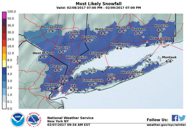
The National Weather Service in has issued a Winter StormWatch…which is in effect from late Wednesday night through Thursday afternoon.
* Accumulations…Snow accumulation of 6 to 10 inches…locally
higher.
* Locations…Long Island…New York City…Northeast New Jersey…the Lower Hudson Valley of New York…and Southern
Connecticut.
* Hazard types…Heavy snow.
* Timing…Late Wednesday night through Thursday.
* Impacts…Hazardous travel due to snow covered roads and poor visibilities. Blowing and drifting snow is possible.
* Temperatures…In the 30s.
PRECAUTIONARY/PREPAREDNESS ACTIONS…
A Winter Storm Watch means there is a potential for significant snow…sleet…or ice accumulations that may impact travel.

In other words, a Winter Weather Watch is the “CONSIDER BUYING BEER” stage of a storm’s development. If we upgrade to a Winter Weather Warning, that means “BUY BEER NOW.”
With a moderate amount of snow Thursday, we don’t anticipate the dreaded “BUY WHISKEY NOW” stage—but stay tuned, as we’ll keep you up to date on any developments.
 Previous Article
 Next Article
 Ask Your Bartender: The Ainsworth Hoboken’s Natasha Javed & Glen De Magalhaes
  Cuomo and Christie Shoot Down Port Authority Overhaul
  Hoboken Mayor Ravi Bhalla Introduces His Slate of Council Candidates for November Election
  PUFF GUY: Hate Speech Incident Allegedly Involving Local Vape Retailer Has Hoboken Officials, Residents Fuming — UPDATED
  DOG AND FUNNY SHOW: Stand-Up and Sketch Comedy to Benefit Companion Animal Placement, Inc. — SUNDAY, OCTOBER 22
  BACK FROM THE DEAD? Rumors Swirl on Resurrected/Revamped Whole Foods Jersey City Deal
  HOBOKEN HUBRIS: Mopping Up After #TeamBhalla’s Tough Tuesday | EDITORIAL
  hMOUTH — Hoboken Was Pricing Out Hipsters Before It Was Cool